|
[About Us] [Links] [Site Map] [Contact & Feedback] |
|
|
||||||
NEWS
 Military
 Space
Space Above Top Secret
 Pic Of The Week
 HOME HOME
|
[Search] |
NASA's ER-2 Airborne Science program |
||||
 
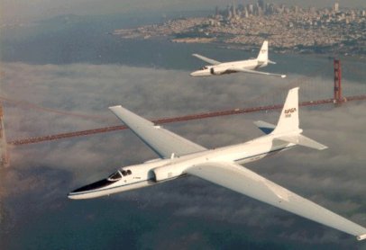
The aircraft, used extensively to study and document weather and other natural phenomena, is based at NASA Dryden Flight Research Center in Edwards, California, but has been deployed around the world for research projects. The ER-2 typically operates at altitudes above 65,000 feet, above 95 percent of the earth's atmosphere, allowing the aircraft to use many of the same sensors similar to those used by orbiting satellites. Program HistoryIn 1981, NASA acquired its first ER-2 aircraft. The agency obtained a second ER-2 in 1989. These airplanes replaced two Lockheed U-2 aircraft, which NASA had used to collect science data since 1971. The U-2s, and later the ER-2s, were based at NASA's Ames Research Center, Moffett Field, CA, until 1997, at which time the ER-2 aircraft and their operations moved to Dryden. Research Since 1991, the aircraft have been used for airborne research for such topics as Earth's environmental system, ozone depletion over Antarctica and improving hurricane predictions. Data and photos obtained by the research projects have been used by NASA, the U.S. Forest Service, Environmental Protection Agency, as well as numerous other domestic and international agencies. Several years ago when a meteorite was seen plunging to Earth in the Yukon, NASA quickly dispatched an ER-2 to fly in its wake, seeking to gather dust particles from this extraterrestrial mass to aid scientific research. The ER-2 has played an important role in high-altitude atmospheric research in recent years. In addition to the POLARIS mission, the ER-2 has participated in several major aircraft campaigns to study the decrease in ozone over the Antarctic and Arctic regions. Other atmospheric experiments have helped to develop improved cloud and radiation parameters for climate models. The ER-2 is uniquely capable of providing data from the top of the atmosphere at fine spatial and temporal resolutions.
On the 28th of October 2003, a NASA ER-2 collected digital images during the southern California fires as demonstration of its emergency response capability to natural disasters such as floods, earthquakes and fires. The southern California wildfire image data was made available to fire front managers several hours after data collection.  To calibrate and validate environmental satellite instrumentation, the ER-2s sometimes fly the same path as the higher satellites, collecting similar information for comparison, and testing sensor prototypes before they are committed to an expensive satellite launch. ER-2 Instruments and Sensors
A wide variety of instruments and sensors have been developed for the ER-2. They are briefly described HERE.
The next two images show the payload configuration for the Polaris mission, the Safari 2000 mission and the configuration for storm observations: Depending on aircraft weight, the ER-2 reaches a cruise altitude of 65,000 feet within twenty minutes. Typical cruise speed is 470 miles per hour. The range for a normal six-hour mission is approximately 2,500 miles, which yields five hours of data collection at high altitude. The aircraft is capable of longer missions of more than eight hours and ranges of more than 3,400 miles. The ER-2 can carry a maximum payload of 2,600 pounds, distributed in the equipment bay, nose area and wing pods. The ER-2 set a world-altitude record for medium-weight aircraft on Nov. 19, 1998, when it reached a height of 68,700 feet above sea level. ER-2 Images


 Related external links:
|
||||
|
|
| Air-Attack.com - All About Military Aviation, Space Projects & News |
|
 |
|
All content © 2001, 2002, 2003, 2004 Air-Attack.com (unless otherwise indicated), all rights reserved. |
||